
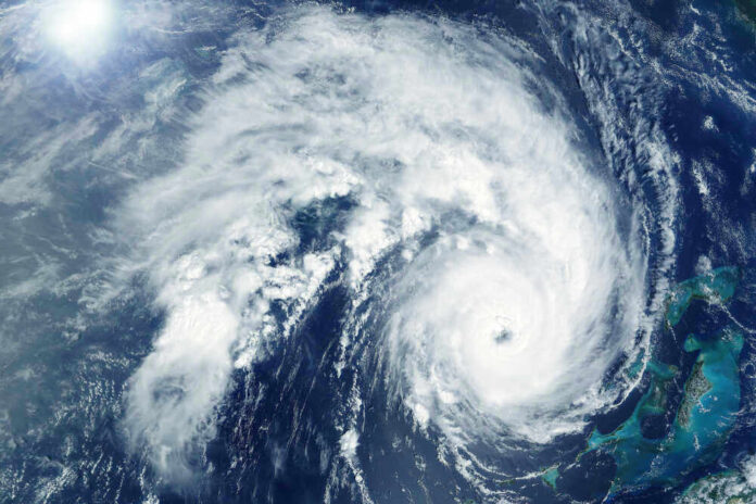
A slow-moving tropical storm named Bertha is sliding toward the Gulf Coast while a hotter, stronger system called Hurricane Fausto quietly spins up in the Pacific, and together they expose how fragile our trust in “official” weather forecasts has really become.
Story Snapshot
- Bertha strengthens near the Florida Panhandle with watches, rain, and surge aimed at the Gulf Coast
- Hurricane Fausto in the eastern Pacific is forecast to intensify rapidly into a major storm
- Media and forecasters send mixed messages about Bertha’s land threat, confusing the public
- Improved forecast skill clashes with low trust and economic pressure along the Gulf
Bertha forms close to land and starts drifting toward the Gulf Coast
The National Hurricane Center designated Tropical Depression Two in the eastern Gulf of Mexico and expected it to reach tropical storm strength, becoming Bertha, within about a day.
By Monday evening, advisories placed Bertha roughly 110 miles south of Panama City, Florida with sustained winds around 40 to 50 miles per hour and a very low central pressure near 998 millibars.
The storm crawled northwest at just a few miles per hour, which meant it spent more time over warm water, feeding on heat while staying close enough to land to keep people uneasy.
The National Hurricane Center forecast called for Bertha to track near or along the northern Gulf Coast over several days, then bend toward Louisiana and Texas. Heavy rain totals of two to four inches, with some spots near six to eight inches, were expected from western Florida through southern Alabama, Mississippi, Louisiana, and into the middle Texas coast.
For coastal communities used to summer storms, those numbers mean flash flood risk, ponding on roads, and stressed drainage systems, especially where growth has outpaced infrastructure.
STORM BREWING ⛈️: Tropical Storm Bertha has formed in the eastern Gulf of America and is forecast to bring rounds of heavy rain, gusty winds and minor flooding to parts of the Gulf Coast. Tropical Storm Watches are in effect from the Florida panhandle to southeastern Louisiana as… pic.twitter.com/gMmkvsGV30
— FOX Weather (@foxweather) July 21, 2026
Watches, surge, and real impacts clash with “no direct U.S. impacts” headlines
Before Bertha even earned its name, the National Hurricane Center and partner outlets highlighted a tropical storm watch from Florida’s Ochlockonee River westward toward the Alabama and Mississippi borders. That watch signaled the real chance of tropical storm conditions within 36 to 48 hours along the Panhandle and nearby coast.
Forecast discussions also mentioned a one to three foot storm surge in vulnerable low-lying areas if stronger onshore winds lined up with the daily high tide cycle.
While those alerts were active, some national coverage framed Bertha as a system that would stay “well west” of Florida with “no direct U.S. impacts,” leaning on a track cone that kept the center offshore. Other outlets, including regional media near New Orleans, spoke bluntly about likely landfall in coastal Louisiana parishes around Thursday morning.
YouTube meteorologists and local television weather teams showed similar track maps but put more stress on the uncertainty after midweek, telling viewers that confidence dropped sharply beyond about 48 hours. That mix of watch headlines, landfall talk, and “no impacts” claims left ordinary people wondering which expert to believe.
Forecast skill has improved, but trust breaks when messages collide
Modern hurricane forecasts are far better than many people realize. In the 1980s, the typical error in a 36-hour storm track could be more than 200 miles; by the 2020s, average miss distances have shrunk to roughly 57 miles. Yet research shows that when users see different forecasts from different sources, trust falls more from inconsistency than from simple inaccuracy.
When Bertha’s track looked similar across maps but the messaging around “threat to land” changed by outlet, the public got the worst of both worlds: mostly accurate science wrapped in confusing talk.
The American Meteorological Society has urged media to pair every forecast with clear statements about confidence and uncertainty, especially for long-range events. That kind of straight talk fits common sense: tell people the likely outcome, admit what is unknown, and let families judge risk for themselves instead of hiding behind softened language.
With Bertha, official text mentioned uncertainty, but some secondary outlets focused more on calming tourism worries than on giving full context about rain, surge, and possible landfall.
Hurricane Fausto builds in the Pacific while Bertha tests the Gulf’s risk culture
While Bertha soaked the Gulf, Hurricane Fausto spun up in the eastern Pacific with model guidance showing rapid intensification into a powerful hurricane, possibly near 110 mile-per-hour winds within three days. Forecast teams pointed to warm sea surface temperatures, enough moisture, and modest wind shear as the ingredients for that fast strengthening.
Fausto’s rise underscored a broader pattern: the basin may be quieter than some past years, but nature still delivers serious storms even in “near normal” seasons.
#Bertha now down to 998mb according to last recon pass and NHC believes there’s enough evidence supports 50mph TS which matches the improvement in SAT presentation we’ve seen to make the shrimp look.
Some of the coldest convection we’ve seen yet as well and like thought after… https://t.co/fchynfWEz2 pic.twitter.com/Z143vuyZYV
— BGWX (@BradyBGWX) July 21, 2026
Put together, Bertha and Fausto highlight how coastal America now faces two storms in every cycle. One is the real system on the map, with rain bands, surge, and wind. The other is the storm in the information space, where national media, niche weather channels, and economic interests push different stories.
For Gulf residents, the lesson is simple. Pay attention to the National Hurricane Center text products, respect the watches and rainfall numbers, and treat vague “no threat” headlines with caution. The science has earned more trust than the spin.
Sources:
apnews.com, nhc.noaa.gov, wusf.org, youtube.com, yahoo.com, foxweather.com, weathertiger.substack.com